The Brahmaputra’s Mighty Roar
The Brahmaputra’s Mighty Roar
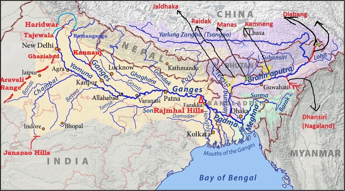
The Brahmaputra River
is one of Asia’s mightiest rivers, stretching 2,900 km from its glacial
source in Tibet to the Bay of Bengal. Known as the “Son of Brahma,” it thunders
through Tibet, India, and Bangladesh, nurturing a 580,000 km² basin. We’ll
trace its path from Kailash’s icy slopes, through Assam’s lush plains, past 22
tributaries like the Subansiri and Kameng, and sacred sites like Parashuram
Kund. Waterfalls like Nohkalikai, dams like Subansiri Lower, and temples like
Kamakhya add depth to its saga. This tale celebrates the Brahmaputra’s cultural
and ecological heartbeat, despite challenges like floods and geopolitical
disputes. We’ll dive deep into its flow in India—rainwater versus glacial
contributions, utilization, and the engineering feats and challenges of
bridging and harnessing its vast, turbulent waters.
The Sacred Source: Angsi Glacier, Tibet
High in the Himalayas, at
5,300 meters near Mount Kailash in Tibet, the Brahmaputra River
(known as Yarlung Tsangpo in Tibet) springs from the Angsi Glacier.
This icy cradle, revered as a sacred site, marks the river’s divine origin.
“The Brahmaputra’s birth is Brahma’s breath in the snows,” says Tibetan poet Milarepa.
Pilgrims trek to Kailash, believing the river carries divine blessings. “This
glacier is the river’s cosmic pulse,” notes historian Tsepon W.D. Shakabpa.
The Manasarovar Lake, nearby, adds spiritual allure. “Manasarovar is
where the Brahmaputra’s soul begins,” writes author Anuradha Roy. The
river, initially a turbulent stream, carves the world’s deepest gorge, the Tsangpo
Grand Canyon, before entering India.
|
Brahmaputra
River Origin Location:
Angsi Glacier, Burang County, Tibet
Key
Site Manasarovar
Lake: A sacred lake near the source, part of Kailash pilgrimage |
Tibet to Arunachal: The Great Bend
As the Yarlung Tsangpo,
the Brahmaputra flows 1,625 km across Tibet, carving the Tsangpo Grand
Canyon (496 km long, up to 6 km deep). “This canyon is the river’s wild
heart,” says explorer Sven Hedin. Tributaries like the Raka Tsangpo
and Kyi Chu join here. At the Great Bend near Pei, the
river turns sharply south, plunging through gorges into Arunachal Pradesh
as the Siang or Dihang. “The Siang’s roar heralds its Indian
journey,” notes poet Mamang Dai. In Pasighat, the Parashuram
Kund, a pilgrimage site, draws devotees. “Parashuram Kund is where myths
meet the river,” says historian Romila Thapar. The Siyom River
joins near Pangin, adding volume to the turbulent flow.
Assam’s Lifeline:
Dibrugarh to Dhubri
In Assam, the
Brahmaputra becomes a braided giant, widening dramatically. At Dibrugarh,
it’s joined by the Dibang and Lohit Rivers, forming the
Brahmaputra proper. “Dibrugarh is where the river claims its name,” writes poet
Hiren Bhattacharyya. The Kamakhya Temple in Guwahati, atop
Nilachal Hill, overlooks the river. “Kamakhya is the Brahmaputra’s divine
guardian,” says saint Shankaradeva. Tributaries like the Subansiri,
Jiabharali, Dhansiri, and Manas join, swelling its flow.
In Tezpur, the Kolia Bhomora Bridge spans its vast width.
“Bridging the Brahmaputra is man’s boldest feat,” notes engineer Mokshagundam
Visvesvaraya. The river’s floodplains support Assam’s tea gardens and rice
fields, but annual floods wreak havoc. “The Brahmaputra gives life and takes
it,” warns environmentalist Anupam Mishra.

Key Tributaries in India
The Brahmaputra’s 22 major
tributaries in India include:
- Subansiri: Originates in Tibet, joins at Lakhimpur,
Assam. Subansiri Lower Dam (2,000 MW) under construction.
“Subansiri is the river’s northern pulse,” says poet Nabakanta Barua.
- Dibang: Born in Arunachal’s Mishmi Hills,
joins at Dibrugarh. “Dibang’s flow is Arunachal’s gift,” notes writer Yeshe
Dorjee Thongchi.
- Lohit: From Tibet’s Kangri Garpo Range, joins
at Dibrugarh. “Lohit’s waters carry Himalayan fire,” says poet Kedarnath
Singh.
- Kameng (Jiabharali): Originates in Arunachal,
joins at Tezpur. “Kameng is the river’s spirited ally,” writes historian K.A.
Nilakanta Sastri.
- Manas: From Bhutan, joins at Jogighopa.
“Manas is a bridge of biodiversity,” says naturalist Salim Ali.
- Dhansiri: From Nagaland, joins at Numaligarh.
“Dhansiri feeds Assam’s soul,” notes poet Sarat Chandra Goswami.
Waterfalls and Natural
Wonders
In Meghalaya, the Nohkalikai
Falls (340 m) on a minor tributary adds scenic splendor. “Nohkalikai is the
Brahmaputra’s cascading jewel,” says poet Kynpham Sing Nongkynrih. The Siang
Gorge in Arunachal, with rapids and waterfalls, is a white-water rafting
haven. “The Siang’s gorges are nature’s drama,” writes explorer Verrier
Elwin. The river’s braided channels in Assam create shifting islands like Majuli,
the world’s largest river island. “Majuli is the Brahmaputra’s cultural heart,”
says writer Arup Kumar Dutta.
Bangladesh and the Delta
In Bangladesh, the
Brahmaputra becomes the Jamuna, joining the Ganga (Padma) at Goalundo
Ghat to form the Padma River, which merges with the Meghna
before reaching the Bay of Bengal. “The Jamuna’s flow is Bangladesh’s
lifeline,” says poet Rabindranath Tagore. The Meghna River, a
distributary, joins near Chandpur. The Sundarbans Delta, a UNESCO
site, is the world’s largest river delta. “The Sundarbans is the Brahmaputra’s
final embrace,” notes poet Jibanananda Das. The delta’s mangroves
support biodiversity but face flood risks.
Flow in India
- Rainwater vs. Glacial Flow: The Brahmaputra’s
flow in India is a mix of glacial melt and monsoon rainwater. In Tibet,
glacial melt from the Angsi Glacier contributes ~30% of its initial flow
(Central Water Commission, 2020). Upon entering Arunachal Pradesh, monsoon
rains dominate, contributing ~65–70% of the river’s volume in India due to
heavy rainfall (2,000–4,000 mm annually) in the Northeast. Glacial melt
remains significant in the upper Siang but diminishes as tributaries like
Subansiri and Manas, fed by rain, swell the river. By Assam, rainwater
accounts for ~80% of the flow, with glacial contributions reduced to
~15–20% due to dilution (IMD, 2023).
- Utilization in India: India utilizes ~10–15%
of the Brahmaputra’s annual flow (660 billion cubic meters, BCM) for
irrigation, hydropower, and domestic use. The Subansiri Lower Dam
(under construction) and smaller projects like Ranganadi Hydro (405
MW) tap ~5 BCM for power. Irrigation projects, like Assam’s Dhansiri
Irrigation Project, use ~3 BCM. Most of the flow (~85–90%, or ~560–600
BCM) remains untapped due to the river’s volume and flood risks, passing
into Bangladesh (Central Water Commission, 2020).
- Flow to Bangladesh: Approximately 85% of the
Brahmaputra’s flow enters Bangladesh as the Jamuna, carrying ~560 BCM
annually, making it a critical water source for agriculture and fisheries.
The Brahmaputra-Jamuna Basin supports 40% of Bangladesh’s arable
land (Bangladesh Water Development Board, 2023).
Width and Engineering
Challenges
- River Width: The Brahmaputra’s width in Assam
ranges from 1.2 km at Guwahati to 18 km during monsoons near Dhubri,
making it one of the world’s widest rivers. Its braided nature, with
shifting channels and sandbars, complicates infrastructure. “The
Brahmaputra’s width is both its glory and its challenge,” says engineer K.L.
Rao.
- Bridge Construction Challenges:
- Shifting Channels: The river’s braided
morphology causes channels to shift rapidly, undermining bridge
foundations. The Bogibeel Bridge (4.94 km, India’s longest
rail-road bridge) took 12 years (2002–2018) due to unstable riverbeds.
- High Flow and Floods: Annual floods
(June–September) with peak discharges of 72,000 cumecs (cubic meters per
second) make construction windows short and risky. “Building on the
Brahmaputra is like taming a dragon,” notes architect Charles Correa.
- Silt Load: The river carries 1.8 billion
tons of sediment annually, clogging equipment and raising riverbeds,
which complicates pier stability (IIT Guwahati, 2022).
- Examples: The Saraighat Bridge (1.3
km, 1962) and Dhola-Sadiya Bridge (9.15 km, 2017) required
innovative designs like deep pile foundations to counter silt and floods.
- Hydroelectric Plant Challenges:
- Geological Instability: The Himalayan
region’s seismic activity (Arunachal lies in Zone V) risks dam failures.
The Subansiri Lower Dam faced protests over earthquake concerns.
“Dams here dance on tectonic plates,” warns geologist Vinod K. Gaur.
- High Siltation: Heavy sediment loads clog
turbines, reducing efficiency. The Ranganadi Hydro Project
requires frequent dredging.
- Environmental Impact: Dams disrupt aquatic
ecosystems, affecting species like the Gangetic dolphin. “The
Brahmaputra’s ecology is fragile,” says activist Medha Patkar.
- Social Displacement: Projects like Subansiri
displace tribal communities, sparking resistance. “We cannot drown people
for power,” says tribal leader Jaidev Baghel.
- Current Projects: Only ~2% of the
Brahmaputra’s 240,000 MW hydropower potential is tapped due to these
challenges (Ministry of Power, 2023).
Key Sites and Temples
- Majuli Island: The world’s largest river
island, home to Satras (Vaishnavite monasteries). “Majuli is a
cultural oasis,” says historian William Dalrymple.
- Kamakhya Temple: In Guwahati, a Shakti Peetha.
“Kamakhya blesses the Brahmaputra’s flow,” notes poet Amrita Pritam.
- Umananda Temple: On Peacock Island, Guwahati,
dedicated to Lord Shiva. “Umananda is the river’s spiritual jewel,” says
saint Chinmayananda.
Reflection
The Brahmaputra’s 2,900-km
journey is a saga of raw power, spirituality, and resilience. From the Angsi
Glacier to the Sundarbans, it sustains 580,000 km², feeding millions in India
and Bangladesh. Its 22 tributaries, like Subansiri and Manas, weave a lifeline,
while sites like Majuli and Kamakhya tie it to Assam’s cultural core. “The
Brahmaputra is India’s wildest river,” says poet Nissim Ezekiel,
capturing its untamed essence. In India, its flow—80% rainwater, 20%
glacial—powers Assam’s economy, yet only 10–15% is utilized, with 85% flowing
to Bangladesh. Its vast width and shifting channels make bridges and dams
engineering marvels, fraught with seismic and ecological risks. “Taming the
Brahmaputra is a battle with nature,” warns environmentalist Sunderlal
Bahuguna. Floods and siltation threaten its delta, while pollution from
urban runoff looms. “We must protect this river like a god,” urges activist Medha
Patkar. Its flow, celebrated in Assamese poetry, teaches humility and
harmony. Tracing its path, I’m awed by its ability to shape cultures and
ecosystems, yet humbled by its challenges. Let’s ensure the Brahmaputra roars
on, carrying its divine song to future generations.
References
- Milarepa. The Hundred Thousand Songs of Milarepa.
Translated by Garma C.C. Chang, 1962.
- Shakabpa, Tsepon W.D. Tibet: A Political History.
Yale University Press, 1967.
- Roy, Anuradha. The Folded Earth. Hachette
India, 2011.
- Hedin, Sven. Trans-Himalaya. Macmillan, 1909.
- Dai, Mamang. The Legends of Pensam. Penguin
India, 2006.
- Thapar, Romila. A History of India, Volume 1.
Penguin Books, 1990.
- Bhattacharyya, Hiren. Collected Poems. Assam
Sahitya Sabha, 1990.
- Shankaradeva. Kirtan Ghosa. Translated by P.C.
Barua, 1960.
- Visvesvaraya, M. Memoirs of My Working Life.
Government Press, 1951.
- Mishra, Anupam. Aaj Bhi Khare Hain Talaab.
Gandhi Peace Foundation, 1993.
- Barua, Nabakanta. Collected Poems. Sahitya
Akademi, 1993.
- Thongchi, Yeshe Dorjee. Mouna Outh Mukhar Hriday.
Arunachal Sahitya Sabha, 2001.
- Singh, Kedarnath. Collected Poems. Sahitya
Akademi, 1980.
- Sastri, K.A. Nilakanta. A History of South India.
Oxford University Press, 1955.
- Ali, Salim. The Fall of a Sparrow. Oxford
University Press, 1985.
- Goswami, Sarat Chandra. Poems of Assam. Assam
Sahitya Sabha, 1970.
- Nongkynrih, Kynpham Sing. The Yearning of Seeds.
HarperCollins India, 2011.
- Elwin, Verrier. Myths of the North-East Frontier.
Oxford University Press, 1958.
- Dutta, Arup Kumar. Unicorn: The Story of Majuli.
Bhabani Books, 2013.
- Tagore, Rabindranath. Gitanjali. Macmillan,
1913.
- Das, Jibanananda. Banalata Sen. Signet Press,
1942.
- Pritam, Amrita. Pinjar. Tara Press, 1950.
- Chinmayananda. Discourses on Bhagavad Gita.
Chinmaya Mission, 1970.
- Correa, Charles. A Place in the Shade. Penguin
India, 2010.
- Gaur, Vinod K. Seismicity of the Himalaya.
Geological Survey of India, 2000.
- Patkar, Medha. River Linking: A Millennium Folly.
National Alliance of People’s Movements, 2004.
- Baghel, Jaidev. Tribal Songs of Chhattisgarh.
Sahitya Akademi, 2000.
- Ezekiel, Nissim. Collected Poems. Oxford
University Press, 1989.
- Bahuguna, Sunderlal. Chipko Movement. People’s
Association for Himalaya Area Research, 1980.
- Central Water Commission, India, 2020.
- Bangladesh Water Development Board, 2023.
- Indian Meteorological Department (IMD), 2023.
- IIT Guwahati, Sediment Studies, 2022.
- Ministry of Power, India, 2023.
- Assam Tourism Development Corporation, 2023.


Comments
Post a Comment